
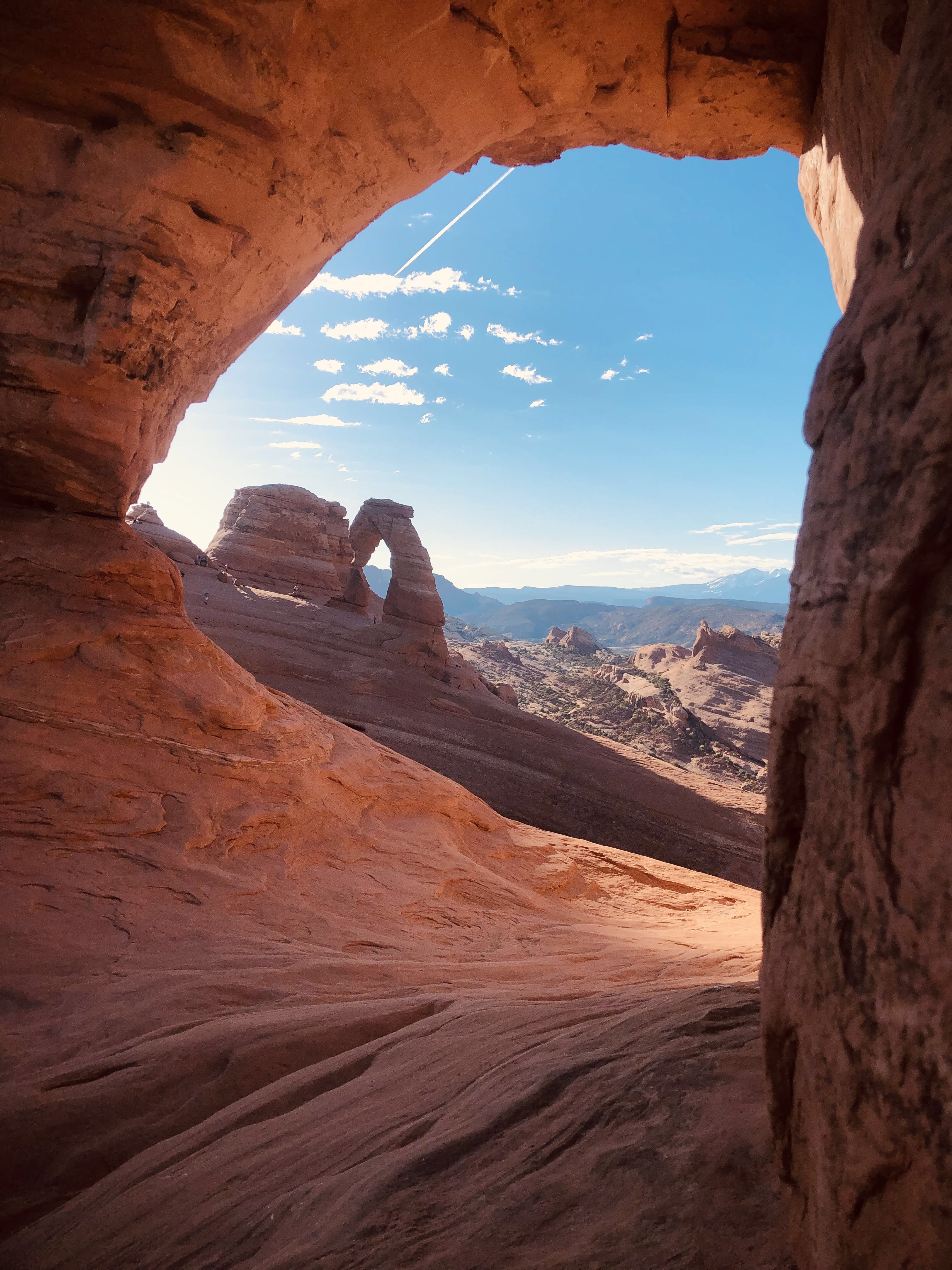
Arches National Park – Delicate Arch
National Parks
All national parks are typically $35 per car entry. If you plan on visiting multiple parks in a calendar year, then I highly recommend getting the Annual Pass for $80. This pass covers you and three others with you! You can find that here online or purchase at any of the National Park or Monuments in person.
Capitol Reef National Park
Bryce Canyon National Park
Zion National Park
Canyonlands National Park
Arches National Park
Devils garden campground $20
Dead Horse State Park
Snow Canyon State Park
Lake Powell
Sand Hollow State Park
Valley of Fire State Park
Goblin Valley State Park
Kodachrome Basin State Park
Coral Pink Sand Dunes State Park
Hiking
Delicate Arch – 3M moderate out & back 610ft elevation gain; great hike to do on a full moon to see stars
Windows Loop & Turret Arch – 1.2M easy loop 154ft elevation gain
Double Arch – 0.6M easy out & back 94ft elevation gain; great hike to do at night to look at stars
Park Avenue Trail – 1.8M easy out & back 298ft elevation gain
Grand staff Trail – 4.3M moderate out & back 387ft elevation gain
Devils Garden Loop Trail with 7 Arches – 7.8M hard loop 1,131ft elevation gain
Sand Dune Arch Trail – 0.3M easy out & back 108ft elevation gain
Landscape Arch Trail – 1.9M easy out & back 259ft elevation gain
Eye of the Whale Arch Trail – 5.1M moderate out & back 410ft elevation gain
Elephant Butte – 1.6M hard loop 597ft elevation gain
Double O Arch Trail – 4.1M moderate out & back 672ft elevation gain
Navajo Arch Trail – 2.9M easy out & back 492ft elevation gain
Wall Arch & Pine Tree Arch – 2.7M easy out & back 465ft elevation gain
Partition Arch Trail – 2.8M easy out & back 469ft elevation gain
Tapestry Arch – 0.6M easy out & back 42ft elevation gain
Destinations by City
Moab
Camping
Right outside – goose island campground $20 if you can’t find one there are many campsites along 128
Free water source right off 128: 38.60301, -109.57551
Rock art BLM camping on moab Kane creek Blvd – 38.55411, -109.58738
Potash Road (FREE): 38.4951, -109.653
Gold Bar Campground ($20): 38.5744, -109.6332
Williams Bottom Campground -Moab ($20): 38.5385, -109.6039
Coffee
Snake Oil Coffee & Moab Coffee Roasters
Food
Breakfast
Moab Diner, Moab Garage Co., Jailhouse Cafe, Love Muffin Cafe
Lunch/dinner
Zak’s, Moab Brewery, Eddie McStiffs, The Spoke on Center, Milts Stop & Eat, Moab Food Truck Park, The Broken Oar, Fiesta Mexicana, Quesadilla Mobilla
Climbing
Wall Street on Highway 279 (potash road) – 130+ climbs on 1M stretch; Routes from 5.3-5.12. Routes are 40-100 ft, mostly bolted, but bring a crack rack. Coordinates – 33.074333, -109.569111. No fee to climb
Ice cream parlor – 7.2M from Moab it has about 26 different climbs; Routes from 5.5-5.9 and some 5.12. Fantastic crag for sport/trad climbing. No fee to climb
In arches national park
Fisher towers – 20M NE of Moab most difficult place to climb but very spectacular. Coordinates – 38.724, -109.308
Indian creek – 37M from Moab; this place is crack city, huge long splitter cracks. Almost all are trad ranging from 5.10-5.12 some ranging from 5.8-5.9. Coordinates – 38.026, -109.54
DO NOT USE COLORED CHALK!
Canyoneering/Repelling
Ephedra’s Grotto – Canyon is located within the Sand Flats recreation area
Chamisa Canyon- located in Canyonlands National Park suited for beginners and intermediate participants. Coordinates – 34.4298° N, 107.7509° W
North Wash Canyons
Leprechaun Canyon Non-technical Hike- 2A II, Leprechauns – 3 Technical Forks – 3A-4A II-III, Sandthrax – 4A III (Slot X) 5.10 C2
WEST FORKS OF BUTLER
Shenanigans – 3B III, Foolin’ Around – 3B III, Woody Canyon – 4B II
HOG CANYONS
Hog One, Hog Two (aka Swine Flue), Hog Three, Miss Piggy
Activities
La Sal Mountain Loop State Scenic Backway; is a 60 mile route is paved and starts about 8 miles south of Moab off US-191 and loops through the mountains down to Castle Valley and SR 128 where it follows the Colorado River back to Moab.
Floating down the Colorado (Go to Moab Gear Trader – 300 S Main Street; they have so many floats and river hats and outdoor gear for a reasonable price)
Canyonlands by Day and Night – family owned company that built RT128 specifically for this tour. It is a dinner cruise with light and sound show
Moab tour company went to slickrock/ sand flats recreation area and rode with a guide in a UTV it was a place with over 40 miles of 4×4 trails and the famous slick rock bike trail. It’s only $2 per day or $5 for 7 days and an additional $5 per vehicle trailer fee
Moab Giants – 112 UT-313, Moab, UT 84532 (Discover Individual Pass – 1 day $24)
Mountain biking – Slickrock Mountain Bike Trail – 8.9M hard loop 997ft elevation gain
Off roading trails
Tower Arch – Difficult trail for 1.3M, moderate for almost all of the way. View of Tower arch and Eye of the Whale Arch. There is some parts where sand is deep and there is a steep sandy climb so keep your speed. Length 14.6M. High clearance & 4W Drive. Starting point N38 47.718 W109 39.490 or N38 42.091 W109 34.818
Hidden Canyon Overlook – Moderate trail, length 6.1M. High clearance & 4W Drive. Starting point N38 44.672 W109 46.791
Willow Springs Road – East trail, get to it in Arches National Park. Views of dinosaur footprints. Length 7.9M. High clearance & 4W Drive. Starting point N38 41.807 W109 41.913
Mineral Point – Easy trail, one moderate part near the ends, amazing views of the Colorado and the Hell Roaring Canyon. Moderate clearance. 12.3M. Starting point N38 35.199 W109 48.347
Gemini Bridges – Easy/Moderate trail. You drive up the mountain right next to i70. Moderate clearance. Campgrounds are up here. On this trail you end at the top of the Gemini bridges. You can repel from the top with the right gear. 13.1M. Starting point N38 39.372 W109 40.626
Bull canyon, Day Canyon – Moderate trail. High clearance, 4W drive. This trail connects from Gemini Bridges trail. You can hike to the bottom of the Gemini Bridge. 3.1M from beginning part of Gemini Bridges trail and then another 4.1M. Starting point N38 35.800 W109 40.870 (Bull Canyon)
Long canyon – East trail. 4W drive. Length 4.1M. Turn is near Dead Horse State Park at the end you see Jug Handle Arch. Starting Point N38 32.693 W109 45.827
Onion Creek, Fisher Towers – East trail. 4W Drive. There are a good amount of water crossings very cool rock formations. Length Onion Creek 9.5M one way & Fisher Towers 2.1M one way. Starting point onion creek – N38 43.439 W109 21.328 fisher towers – N38 43.937 W109 20.714
Colorado River Overlook – Moderate trail. High clearance, 4W Drive. Trail starts in park, wonderful drive into the canyon and of the river. Length 14M. Starting point N38 10.148 W109 45.626
Bartlett Wash Road – Easy trail 9.7M N38 43.630 W109 43.350. Can use this trail to get to Tusher Tunnel. If you go to the end of the trail and go left you go to the highway 313 or right to Dubinsky Well Road and on that for about 7 miles to lead you to Spring Canyon Point Road for the Dellenbaugh Tunnel Trail.
Tusher Tunnel – Easy trail 4.9M; N38 43.626 W109 43.351. Park at the end and after a short walk you will get to Tusher Tunnel.
Dellenbaugh Tunnel, Secret Spire – moderate trail 1.8M to Tunnel & 0.4 to Secret Spire. For the tunnel at 1.2M follow along the North side of the slickrock and curve right, at the end of the wash you will find a water-carved trench.
TIPS: When off roading don’t go alone unless you have all the right gear Incase you get stuck. A tow rope and an extra one,high jack, shovel, sand boards. Watch the weather do not go if there is a chance of rain flash floods happen regularly and might be hard to get to some trails or out if you are stuck. Make sure to bring enough water and have some type of off roading book for the area to help direct you on the trail, a compass, and a map.
Hikes
Grand staff canyon trail – 4M RT 396ft elevation gain: Hikes through water shaded in some spaces definitely have a good amount of water and start early
Mill creek trail – 1.8M RT – 65ft elevation gain
Corona and Bowtie Arch – 2.3M out & back 469 elevation
Camping for Utah
Close to River – Capitol Reef (FREE) : 38.28561, -111.11856
Fish Lake National Forest Boondocking off i70 (FREE) : 38.56951, -112.46441
Hurricane Cliffs Campsites 49-54 – Zion (FREE) : 37.2072, -113.2402
Hurricane Cliffs Campsites 55-56 – Zion (FREE) : 37.2027, -113.2323
Zion Scenic Byway Dispersed Camping (beautiful sunset) (FREE) : 37.254, -112.769
Smithsonian Butte Dispersed Camping (FREE) : 37.1297, -113.0757
Dalton Wells Road Dispersed Camping (FREE) : 38.7112, -109.7033
Willow Springs Trail Dispersed Camping (FREE) : 38.6967, -109.6751
Salt Lake City
TIPS FOR THIS STATE: if you have coolers use blocked ice inside it, make sure you got your river hat, your sunscreen, watch out for scorpions at night, make sure everything is tied down because a wind storm might be coming your way, have the most fun with the biggest smile and do something rad!!!!
